Client trust isn't built on promises; it is built on verifiable geographic dominance. When an institutional investor can visually confirm that your firm has completed 47 commercial projects within a 30-mile radius of their proposed development site, the conversation shifts from "prove your capability" to "when can you start?" Interactive project maps are the most psychologically powerful digital asset a commercial builder can deploy to win enterprise contracts.

The Geography of Trust in Commercial Construction
In the commercial construction sector, developers are fundamentally risk-averse capital deployers. When an institutional investor, a hospital board, or a property management firm awards a $50M+ contract, they are aggressively protecting their capital against every conceivable risk vector. They do not want to hear about your "dedication to quality" or your "family-owned values." Those are meaningless platitudes that every contractor in the Yellow Pages claims. They want raw, undeniable, geographically verifiable evidence that you possess the logistical capacity to execute in their specific territory.
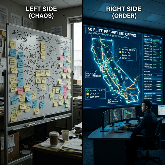
Most contractors attempt to prove their capabilities by burying project site photos in a disorganized, archaic "Portfolio" dropdown buried three clicks deep in their website navigation. This forces the decision-maker to hunt for relevance like an archaeologist sifting through rubble. They have to click through 40 thumbnails hoping to find one project that's geographically or typologically similar to what they need. This friction is a conversion killer. Every additional click required to validate your capability increases the probability that the prospect abandons your site and moves to a competitor whose evidence is immediately accessible.
Elite builders eliminate this friction entirely. They deploy Interactive Project Maps — highly engineered, geographic visualizations of their exact operational footprint, active construction pipelines, and completed commercial builds. When a prospect lands on the page, they immediately see a map of California (or whatever their operational territory is) plastered with hundreds of color-coded pins. Each pin represents a verifiable project with specific data: project name, square footage, contract value, completion date, and high-resolution photography. The prospect doesn't have to hunt for evidence. The evidence hunts them.
The Static Portfolio Problem
A traditional portfolio page is a passive, linear list that requires the prospect to do all the cognitive work of extracting relevance. An interactive map is an active, spatial visualization that instantly communicates geographic density, operational scale, and territorial dominance. Research in spatial cognition demonstrates that humans process geographic data 60,000 times faster than text. Your competitor's 40-thumbnail portfolio gallery literally cannot compete with the instant visual impact of a map showing 200 pins concentrated in the prospect's target market.

Weaponizing Scale: Showing Instead of Telling
When a prospective investor visits your website, an interactive map serves as an immediate, silent assertion of dominance. Seeing a map of California saturated with hundreds of distinct, color-coded pins — each representing a $5M+ commercial build, a municipal contract, or an active high-rise site — shatters any doubt regarding your firm's operational infrastructure before a single word of copy is read.
This is the critical difference between claiming "We serve all of Southern California" and actually proving it with irrefutable visual evidence. The psychology is unassailable. When a prospect zooms into their exact zip code and discovers three massive commercial projects you successfully completed within half a mile of their proposed development site, you have established an instant, unbreakable psychological barrier to entry for every competitor who doesn't have equivalent geographic evidence. The prospect's internal monologue shifts from "Can this firm handle our project?" to "This firm has already proven they own this territory."
The technical implementation should leverage a customized Mapbox or Google Maps API integration with your CMS database. Each project pin should be dynamically generated from your project database, pulling real-time data including project status (completed, active, pre-construction), contract value range, building type classification, total square footage, and a thumbnail gallery. The map should support smooth zoom, pan, and clustering so that at a metropolitan zoom level, dense project areas display aggregated cluster counts (e.g., "47 projects") that expand into individual pins as the user zooms in. This clustering behavior is itself a dominance signal — a cluster showing "47 Projects in Orange County" communicates more authority in a single glance than 47 individual case study pages ever could.
The SEO Architecture of Mapping
Beyond visual intimidation, an interactive project map is a brutal SEO mechanism. Real-estate developers search geographically: "commercial builders in Irvine" or "luxury contractors near Santa Monica." By creating individual, URL-optimized hub pages for each plotted pin, you generate hundreds of hyper-local landing pages. Every project pin becomes an SEO asset driving organic B2B traffic directly into your pipeline, signaling absolute relevance to Google's local clustering algorithms.

Eliminating the "Risk Factor" for Investors
An interactive map allows you to categorize your dominance with surgical precision through advanced filtering capabilities. Plotted pins shouldn't be static, undifferentiated dots on a screen. They should be robust, multi-dimensional filtering systems that allow prospects to self-select the evidence most relevant to their specific project type. A developer looking to build a medical facility should be able to filter your map exclusively for "Healthcare Infrastructure" and instantly see only the medical projects you've completed across the state.
When they apply that filter and see a concentrated history of flawless medical builds — each pin expandable to reveal high-resolution construction photography, exact completion dates, total contract values, and budget adherence metrics — you have de-risked the investment in their mind. You are no longer an anonymous contractor submitting a bid alongside 15 others. You are an established institution in that specific vertical with verifiable, geographic proof of expertise that no competitor can fabricate.
The filtering taxonomy should mirror the commercial construction verticals your firm targets: Healthcare & Medical, Hospitality & Hotels, Multi-Family Residential, Industrial & Warehouse, Educational & Institutional, Municipal & Government, Retail & Mixed-Use, and Corporate Office. Each filter category should display a project count badge so the prospect can immediately gauge your depth of experience in their specific sector before even applying the filter. A badge showing "23 Healthcare Projects" next to the filter option communicates institutional authority before a single click is made.
- Geographic Clustering: Aggregate project density at zoom levels to visually demonstrate territorial dominance in specific metro areas and counties.
- Vertical Filtering: Category-based filters (Healthcare, Hospitality, Industrial, Education, etc.) with project count badges for instant credibility signaling.
- Pin Detail Panels: Each pin expands to reveal project photography, contract value, square footage, completion date, and architect/owner information.
- SEO Hub Pages: Every pin links to a dedicated, URL-optimized project page that feeds Google's local search algorithms with hyper-targeted geographic content.

Digital Territory Acquisition
The most profitable commercial builders do not sell construction services; they sell certainty. An interactive project map is the ultimate digital tool to project certainty at geographic scale. It validates your logistical capacity, proves your historical competence across specific building types, and transforms your website from a passive digital brochure into a compelling, geographic asset that actively wins contracts.
Consider the competitive mathematics. If you have 150 completed projects mapped across Southern California and your closest competitor has a static portfolio page with 20 thumbnail images, the visual disparity in perceived capability is approximately 7.5x. That perception gap directly translates to bid preference. When an RFP committee is evaluating three shortlisted firms and one of them presents an interactive map demonstrating overwhelming geographic presence while the other two present generic portfolio pages, the psychological advantage is insurmountable.
The firms that deploy interactive project maps today are building a compounding digital asset. Every new project completed adds another pin to the map, another SEO hub page to the sitemap, and another data point reinforcing your territorial authority. Over 24 months, a firm completing 30 projects per year will have added 60 new pins, 60 new landing pages, and 60 new geographic proof points that competitors who started late cannot replicate without actually completing the physical work. This is the ultimate competitive moat — it cannot be faked, it cannot be shortcut, and it compounds in value with every project you deliver.

Command Your Territory with Lemonade Ideas
If your website relies on a static portfolio, you are losing high-ticket bids to builders who visually prove their geographic dominance. Lemonade Ideas engineers cutting-edge interactive mapping architectures for elite California construction firms.
Build My Project Map